Where has lidar been used in smart infrastructure?
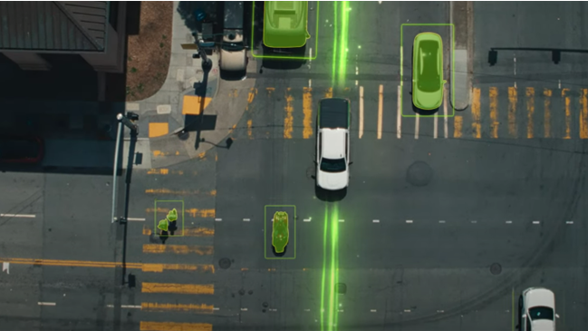
Imagine you’re making a sharp right turn at a green light, but an unseen pedestrian is crossing the street just around the corner. Hopefully you can hit the brakes in time, but you still risk a rear-end collision from a driver behind you. In this scenario, a lidar-enabled smart intersection can mitigate or eliminate accident risk.
This is just one example of how lidar is making a difference at traffic intersections. Lidar collects high-fidelity data 24/7 to monitor vehicles and pedestrians, enabling intelligent analytics to help understand traffic patterns, improve high-risk areas and reduce wait times.
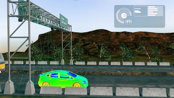
In tolling applications, lidars with ultra-high scanning speed and data rate can enable very detailed and accurate 3D profiling of vehicles passing at highway speeds. This helps modernize tolling infrastructure worldwide by facilitating free-flow, electronic toll collection, significantly reducing traffic congestion and toll leakage.
Lidar can be used to monitor individuals and groups of people without recording biometric data, making it an ideal technology for security, facility management and crowd analytics. Combined with perception software, lidar enables real-time 3D tracking to help operators understand footfall traffic, manage queues and improve merchandizing, as well as identify attention-worthy behaviors such as clustering, loitering, intrusion and tailgating.
Our lidars have been making real-world impact in global cities in North America, Europe, Africa and Asia, transforming cities and spaces with enhanced safety and efficiency.
What types of data does lidar capture?
Lidar data is reliable, undisrupted, and unaffected by external lighting conditions. This sets lidar apart from sensor technologies like camera, making it a preferred choice for many low-light environments, both outdoors and indoors. By emitting its own laser pulses, lidar ensures a reliable and consistent stream of data, enabling precise imaging 24/7.
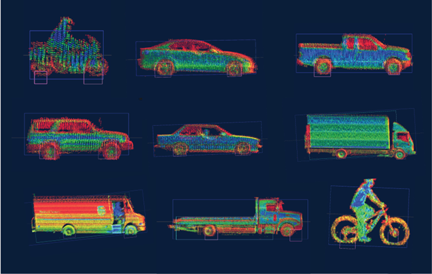
Lidar data is 3D, high-fidelity and real-time. Unlike camera, which is 2D, lidar has the inherent capability of providing depth information without relying on AI-based computer vision. This enables accurate object detection, tracking and classification based on size and real-time location and speed. Compared to radar, which has much lower angular resolution, lidar excels in object differentiation and precise localization. Lidar operates in real time, enabling accurate and efficient decision making in dynamic situations, such as busy traffic intersections and retail environments.
Lidar data is 100% anonymous. Lidar sensors do not collect biometric data, such as facial features. Nor do they track your digital footprint, unlike Wi-Fi or Bluetooth-based analytics. In most smart infrastructure use cases, personally identifiable information is more of a burden than an asset. While lidar is adept at understanding the movements and behaviors of people, either as a group or as individuals, it does not compromise privacy. This is especially vital in an age where personal data has been widely misused and abused. The anonymity of lidar data also helps minimize AI bias based on race, gender and age, just to name a few.
Lidar enables behavior-based data analytics, outputting intelligent, lean data to streamline decision making and reduce data transmission and storage costs. It provides the essential details needed to help create safer, smarter spaces.
Can lidar fully replace camera in smart infrastructure applications?
It really depends on the application. Each sensor technology has its own unique capabilities and use cases. Camera will remain an essential technology where identification is needed, for example, facial recognition and license plate recording.
When the analytics are more behavior-based, lidar provides a more ideal solution than camera. Lidar’s use cases include traffic management and optimization, urban planning, facility management, retail analytics, public safety, vulnerable road user protection, infrastructure maintenance and so forth.
In those applications, lidar often provides increased coverage due to its wider field of view and longer range. It also enhances the system’s reliability due to its uninterrupted performance 24/7. Lidars are suitable for many places where cameras are prohibited due to privacy concerns, such as schools, hospitals and critical infrastructure.
In some cases, lidar can work alongside camera to optimize a smart system’s efficiency and accuracy. Surveillance is a great example. Lidar can detect and track suspicious individuals or dangerous crowd behaviors from a long distance, helping the system decide whether further verification is needed. Once lidar flags breaching, loitering, tailgating and clustering, the camera can be engaged to identify the object in question. This helps protect the privacy of those uninvolved and reduce the operational cost. Traditionally, CCTV needs to be monitored by the staff around the clock; newer systems using computer vision to flag incidents in video footage suffer from high false positive and false negative rates. Using lidar not only helps reduce staff engagement but also mitigates challenges in data transmission and computing.
Are lidar-based perception solutions for smart infrastructure the same as those for automotive applications?
Automotive lidars are embedded inside vehicles that move all the time. Therefore, automotive perception solutions need to factor in ego motion, which means the real-time movement of the sensor as it scans the environment. Ego motion adds to the complexity of real-time distance calculation in automotive lidar perception, or “dynamic perception”. This applies to some of the smart infrastructure use case, where the lidar-equipped smart system moves around as it works.
However, in most smart infrastructure use cases, the lidar is integrated into a still system or fixed structure, such as a gantry or a pole. The stationary nature of the sensor makes distance calculation easier, contributing to a rich portfolio of features of what we call “static perception”.
While automotive perception and smart infrastructure perception share the same end goal of increasing safety and efficiency, they enable vastly different features. Lidar perception solutions for smart cities and spaces focus on tracking how people and vehicles move around in a given zone and interact with each other. This helps flag potential incidents, identify areas for improvement and enhance management and planning. Using Cepton’s Helius Smart Lidar System as an example, some of the popular lidar perception features in the smart infrastructure setting are configurable zones, object classification, people and vehicle counting as well as real-time monitoring of dwell time, distance and speed.
When it comes to integration, lidar perception solutions for smart infrastructure have the advantage of being deployed through flexible setups, sometimes in controlled environments. This enables a plug-and-play solution for system integrators across various industries. Helius has been widely deployed by over 100 customers and partners to transform traffic intersections, retail stores, airports, stadiums, corporate campuses and industrial facilities.